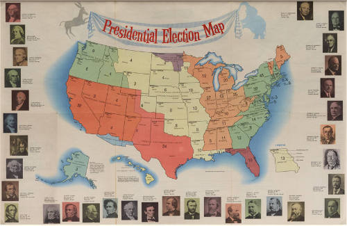
1960 presidential election map and score card
Object number2001.005.0027
Date1960
ClassificationsBooks
ObjectBooklet
Credit LineKathleen Morrow Whatley Collection/The Sixth Floor Museum at Dealey Plaza
MediumPaper
DimensionsFolded: 10 1/4 x 5 1/4 in. (26 x 13.3 cm)
Unfolded: 20 1/2 × 31 1/2 in. (52.1 × 80 cm)
Unfolded: 20 1/2 × 31 1/2 in. (52.1 × 80 cm)
Collections
Description1960 Presidential Election Scoreboard published by Rand McNally and distributed by the First National Bank in Dallas and WFAA-TV Channel 8. When folded it seems like a booklet, but when unfolded it is a map on one side and on the other an election score card with additional information about the role of president. It includes such information as a list of U.S. presidents and their party affiliations, the qualifications required of candidates for the presidency, a description of the structure of the American federal government and an explanation of how the electoral college works. On the map, each state is marked with the year it became a state, its population, the number of electoral votes it has, and its capital, as well as the dates and methods by which each area joined the United States. The document makes no reference at all to the specific candidates running for office in 1960.
This image is not available online larger than a thumbnail to protect the copyright of its creator(s). For a more detailed examination of this item, please schedule an appointment in the Museum’s Reading Room.
Curatorial CommentaryAlaska and Hawaii both became states in 1959. This map reflects the first time that 50 United States voted in a federal election. - Ani Simmons, Education Coordinator